|
  
> History
> Space Craft
> Unmanned Space Programs
> Animals in Space
> Human in Space
> Human in Moon
> Manned Space Programs
> Space Station
> Voyager 1
> Voyager 2
> Hubble Space Telescope
> Recent & Future Developments
   
|
The long history of
myths, dreams, fiction, science, and technology culminated in the dramatic
launching of the first artificial orbiting Earth satellite, Sputnik 1, by
the USSR on October 4, 1957. Sputnik Zemli, meaning “travelling companion
of the world” is the full Russian name for an artificial satellite, a
companion of the Earth as it travels around the Sun.
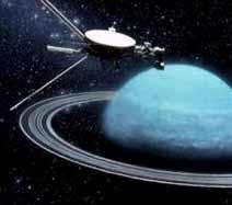 |
Voyager 2 Approaching Uranus
This artist’s conception shows the final
approach of the unmanned spacecraft Voyager 2 towards the planet
Uranus on January 24, 1986. Voyager 2 discovered four new rings and
ten new moons around Uranus. |
Early Artificial Satellites
Sputnik 1 was an aluminum sphere, 58 cm (23 in) in diameter, weighing
83 kg (184 lb). It orbited the Earth in 96.2 minutes. The elliptical orbit
of the satellite carried it to an apogee of 946 km (588 mi) and a perigee
of 227 km (141 mi). The sphere contained instruments which, for 21 days,
radioed data concerning cosmic rays, meteoroids, and the density and
temperature of the upper atmosphere. At the end of 57 days the satellite
re-entered the atmosphere of the Earth and was destroyed by aerodynamic
frictional heat.
The second artificial Earth satellite was also a Soviet space vehicle,
called Sputnik 2. It was sent aloft on November 3, 1957, with a dog named
Laika aboard, and it relayed the first biomedical measurements in space.
Sputnik 2 re-entered the atmosphere of the Earth and was destroyed after
162 days aloft.
While Sputnik 2 was still in orbit, the United States successfully
launched its first Earth satellite, Explorer 1, from Cape Canaveral (named
Cape Kennedy 1963-1973), Florida, on January 31, 1958. The 14-kg (31-lb)
cylindrical spacecraft, 15 cm (6 in) in diameter and 203 cm (80 in) long,
transmitted measurements of cosmic rays and micrometeoroids for 112 days
and gave the first satellite-derived data leading to the discovery of the
Van Allen radiation belts around the Earth.
On March 17, 1958, the United States launched its second satellite,
Vanguard 2; a precise study of variations of its orbit showed that the
Earth is slightly pear-shaped. Using solar power, the satellite
transmitted signals for more than six years. Vanguard 2 was followed by
the American satellite Explorer 3, launched on March 26, 1958, and by the
Soviet satellite Sputnik 3, launched on May 15. The 1,327-kg (2,925-lb)
Soviet spacecraft measured solar radiation, cosmic rays, magnetic fields,
and other space phenomena until the craft’s orbit decayed in April 1960.
[Top]
Un-manned Lunar Mission
As the closest neighbour of the Earth, the Moon has been
the objective of many space missions. In 1958 the first attempts by the
United States and the USSR at lunar probes failed. The Russian Luna 2,
launched on September 12, 1959, hit the Moon 36 hours later. Since that
date, many moon shots have been made by both countries, with mixed
results. The first photographs of the far side of the Moon were taken by
Luna 3, which was launched by the USSR on October 4, 1959. One of the most
dramatically successful moon shots was the mission accomplished by Ranger
7, launched by the United States on July 28, 1964. Just before hitting the
side of the Moon that faces the Earth, it transmitted 4,316 television
pictures of the lunar surface from altitudes of about 1,800 km (1,120 mi)
to about 300 m (1,000 ft), giving Earth-bound human beings their first
close-up view of the Moon.
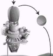 |
Luna Lander
The Soviet Union’s Luna programme was
a series of missions to the moon between 1959 and 1970. It included
orbiters and probes. The later type of probe, which was first used
on Luna 9 in 1966, made a controlled descent to the Moon’s surface,
then released a small capsule. The capsule had a weighted base, so
it rolled upright. It then opened its flaps, exposing a television
camera and communciations antennas. |
On January 31, 1966, the USSR launched Luna 9, which made
the first soft landing on the Moon—that is, it landed without being
destroyed—and transmitted back to Earth the first photographs from the
lunar surface. The United States followed on May 30 with Surveyor 1, which
also made a soft landing. It sent back to Earth 11,150 photographs.
Aside from the scientific information that was gathered, much of the
interest of the lunar missions centred on the American programme to land a
man on the Moon. To this end, a number of further unmanned moon flights
were undertaken, among which were two soft landings made by Surveyors 3
and 5 in 1967. Both craft, after taking about two days for their journeys,
sent back to Earth a large number of television pictures of the lunar
surface. Surveyor 3 also picked up samples of lunar soil and examined them
by television camera, while Surveyor 5 chemically analysed the lunar
surface, using an alpha-particle scattering technique—the first on-site
analysis of an extraterrestrial body.
Another spacecraft that helped pave the way for the manned lunar landings
was Lunar Orbiter. In 1966 and 1967, five Lunar Orbiters orbited the Moon,
relaying thousands of photographs to Earth. From these photographs, the
landing sites for the Apollo moon-landing programme were selected .
Two other unmanned, automated lunar projects by the USSR are noteworthy.
The Luna 16 spacecraft, launched on September 12, 1970, landed on the Moon
and placed about 113 g (4 oz) of lunar soil in a sealed container that was
then launched from the Moon and recovered in the USSR. Luna 17, launched
on November 10, 1970, soft-landed an automated lunar-roving vehicle,
Lunokhod 1, equipped with a television camera and solar batteries. Over a
period of 321 Earth days the vehicle, controlled from the Earth, travelled
10.5 km (6.5 mi) on the Moon, relaying television pictures and scientific
data. Luna 21 in 1973 repeated this performance, placing Lunokhod 2 on the
Moon.
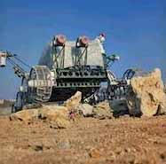 |
Lunokhod Rover
In 1970 and 1973 the Soviet Luna
programme delivered two rovers to the Moon. These eight-wheeled
robotic explorers rolled down ramps to leave their parent spacecraft
(Luna 17 and Luna 21 respectively). The Lunokhods carried cameras,
soil analysers, and solar panels for power. |
After a lull in lunar exploration following the manned
lunar landings, the United States returned to the Moon in 1994 with
Clementine, an unmanned spacecraft which mapped the surface in
unprecedented detail, returning nearly 1 million images in 11 visible and
near-infrared wavelengths between February 19 and May 3.
[Top]
Scientific Satellites
As space-launch vehicles (rocket boosters) and scientific
measuring devices became more reliable, a wide variety of satellites were
developed. Scientists were eager to obtain data and make accurate studies
of the Sun, other stars, the Earth, and space itself. The enveloping
atmosphere of the Earth prevents such data from being obtained from the
Earth’s surface, except in a limited way through the use of high-altitude
balloons.
In the United States, many astronomical satellites have been launched.
Since 1962, for example, the Orbiting Solar Observatories (OSOs) have
studied the Sun’s ultraviolet, X-ray, and gamma radiation. Pioneer
satellites have studied cosmic radiation, the solar wind, and the
electromagnetic characteristics of space. The Orbiting Astronomical
Observatories (OAOs) have observed stellar radiation, and Orbiting
Geophysical Observatories (OGOs) have studied the relationships between
the Sun, the Earth, and their space environment. The Infrared Astronomy
Satellite (IRAS), an Anglo-American project launched in 1983, has probed
the hidden reaches of our galaxy. The Hubble Space Telescope (HST),
launched by the space shuttle Discovery in 1990, has transmitted valuable
images—some of never-before-observed phenomena—back to astronomers on
Earth. The Compton Gamma-Ray Observatory (CGRO), launched by the Space
Shuttle Atlantis in 1991, detected more than 400 gamma-ray sources and
2,500 gamma-ray bursts during its nine years of operation.
Two major new scientific satellites, NASA’s Chandra X-ray Observatory and
ESA’s XMM-Newton X-Ray Observatory, were launched in 1999. They have
already provided large amounts of data on the X-ray sky, including images
of active galactic nuclei and nebulae bathed in X-rays, as well as
pinpointing many more X-ray sources at the outer reaches of the universe.
[Top]
Application Satellites
This class of unmanned spacecraft also performs useful
functions for the earthbound scientist. The three general classifications
of such satellites are communications, environmental, and navigation
satellites.
Environmental satellites observe the Earth and its atmosphere, and
transmit images for a variety of purposes. Weather satellites provide
daily transmissions of temperatures and cloud patterns. One example is the
geosynchronous meteorological satellite, such as Meteosat (stationed above
longitude 0°) and GOES (Geostationary Operational Environment Satellite,
stationed above longitudes 75°W and 135°W), which provide pictures of
large areas of the Earth’s surface at regular intervals. Two such
satellites can cover an entire continent and adjacent ocean areas.
The US Landsats observe the Earth with multispectral optical scanners and
transmit the data to ground stations. Processed into colour images, these
pictures reveal data of great range and great potential value. Information
on soil characteristics, water and ice quantities, coastal-water
pollution, salinity, and insect blights of crops and forests are obtained.
Even forest fires can be detected from Earth orbit. Study of folds and
fractures in the Earth’s crust helps geologists to identify deposits of
oil and minerals. SPOT (Système Probatoire pour Observation de la Terre),
a European satellite launched in 1985, transmits images that show the
Earth in even greater detail than Landsats can.
Earth observation satellites are used by the United States and other
countries to obtain images of military value, such as of nuclear
explosions in the atmosphere and in space, ballistic-missile launch sites,
and ship and troop movements. In the 1980s and again in the early 2000s,
controversy was aroused by the American proposal to develop a satellite
antiballistic missile defence system making use of laser technology.
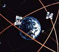 |
GPS System
The Navstar Global Positioning System (GPS) is
a network of 24 satellites in orbit around the earth that provides
users with information about their position and movement. A GPS
receiver computes position information by comparing the time it
takes for signals from three or four different GPS satellites to
reach the receiver |
Navigation satellites provide a known observation point
orbiting the Earth that, when observed by ships and submarines, can fix
the vessel’s position within a few yards. The United States has developed
a Global Positioning System (GPS) employing 24 satellites, which is
capable of providing location information to ships and aircraft, drivers,
and even walkers.
[Top]
Planetary Studies
Beyond the Moon, spacecraft have landed on Mars and Venus,
have flown by every planet and have made comet studies.
For more information about these explorations go to
Solar Bodies.
[Back] [Top] [Next] |